

Club Night – May 2012
The Club held its 36th Annual Meeting on the 14th May 2012. There are slight changes to office bearers with Bronwyn McCone remaining President and Neville Corry becoming treasurer. Uwe Grasmueck is newsletter editor. Subs were increased slightly for family and social members.
The Club is a nominee for the Trust Power Otago Community Services Award.
Mountain Safety are running a First Aid course in June.
Trips organized by the club over the last month included a South Temple social trip by 4 members.
The Hoods Creek Reopening day was held on the 15th April in brilliant weather with about 90 attending. Groups then walked the various tracks in the Herbert Forest which is owned by Blakely Pacific.
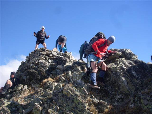
Mount Buster near Naseby was climbed on a blustery day by 8 members, with a visit also to the Buster gold diggings, which at 1200m are the highest gold diggings in New Zealand.
The Routeburn Caples circuit was walked by 5 members. Incidents they came across included saving the Routeburn Falls hut from burning down upon walking into the hut to find a white spirit stove burning out of control. Luckily there was only smoke damage. There was a search and rescue operation happening in the Caples Valley, with helicopters everywhere. Members were impressed with the quality upgrade of the McKellar Saddle track.
The Wednesday Walkers climbed Station Peak from Little Roderick, walked the Benmore Walkway to the peninsula with brilliant autumn colours, climbed Mt.Difficulty from The Dasher, and did an anticlockwise circuit which included the Earthquakes Reserve near Duntroon.
Coming Club trips are the Elephant Hill – Mussen circuit on the 20th May, Dunedin Hills including the Pipeline and Swampy on the 27th May, and Otehake River in Arthurs Pass on Queens birthday weekend, where a soak in the hot pool is a must do. More details are on the NOTMC website.
Guest speakers were Club members Ann and Steve Leidecker who walked several day trips in the Appenine and Apuane Mountain ranges of Italy in September last year with a group of 12 friends.
They based themselves in Sommocolonia where they rented a very reasonably priced villa. Sightseeing in the pretty towns of Lucca and Barga started the trip. Then a day walk, including an extensive limestone cave tour, in the Apuane foothills. The views from the steep ridges were spectacular.
The third day saw them in the Appenine foothills climbing 2054m Mt.Prado, the route taking them up through the green beech forest and along a long ridge above the tree line.
The next day saw them walking through colourful heather, tussock, and wild bilberry meadows close to their Villa in the Appenine’s. Mt.Rommechio at 1700m and Cima del Ormo at 1850m were their objectives with a 24k round trip.
The last walk showed the limestone and high grade marble of the Opuane Mountains, where they visited a delightful church built into the cliff face, and saw the marble quarry that Michelangelo used for his masterpieces.
The pictures and talk were an enticement to members to visit this scenic part of Italy with its many well marked tracks.
Routeburn/Caples – 10th-3th May 2012

Friday morning was misty around the tops but we still had clear views of the waterfalls, Lake Harris and the stunning scenery in the upper basin. We decided not to climb Conical Hill from the Harris Saddle as the views from the top would have been poor. Instead we sat in the public shelter and had morning tea. From here the track has been re-routed, passing several tarns and then linking up with the old track to traverse the Hollyford Faces. Fog hung in the valley below so we were unable to see Gunns Camp and the secenery in the Lower Hollyford Valley. The sun appeared briefly as we arrived at McKenzie Hut in time for lunch. Alterations here were also being carried out on the guided walkers’ accommodation as we wandered on passing another toilet on the side of the track and then on to Earland Falls and Howden Hut. Five DOC staff were waiting for a helicopter to come and pick them up after having spent the last few days there replacing the warden’s quarters with a new roof and replacing the hut windows with double glazed ones. We again watched as the pilot carefully winched up the old windows and repositioned some large containers and fadges. The workers were then taken out to the Divide to drive back to Te Anau.
After settling in our bunks for the night we were woken at 11pm by a party of 6 youths and their leaders from Invercargill. Silence returned after midnight.

By Sunday morning the rain had stopped so we set off down the valley in fine weather to the Mid Caples Hut for morning tea. As we soaked up the sunshine on the veranda the Iroquois landed below on a terrace and airlifted the SAR personnel once again. The scenario for the SAR exercise was that they were searching for two persons reported missing while researching a route suitable for an adventure race.The sound of the helicopter was heard coming and going as we made our way down the picturesque Caples Valley to the bridge across the Greenstone River. We crossed the bridge to have lunch in the sunshine and then back again to join the track and on out to the car park where our transport was waiting to take us to the Routeburn Shelter. Next stop was the Glenorchy Camping Ground for a shower and then the Omarama Hotel for tea .
Although we encountered helicopters at every hut it was a thoroughly enjoyable trip which I would highly recommend to anyone of average fitness and my thanks go to Bill, Steve, Robbie and Maurice for the great company. Phyllis


Mt. Buster – April 2012
At the car park it was a wee bit windy but not too bad, so we picked the ridge we were going to go up and headed off on our climb. The climb was not too bad apart from the tussocks that we had to push though; they were quite big in places. The higher up we got the more the wind picked up and when we got to the top which took about two hours it was blowing a gale. We tried to find a place out of the wind to have lunch, but this was not easy. Robbie found a place, it was not the best but we had some shelter if we got down low.
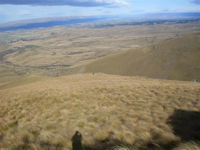
After lunch we realised we were not quite on Mt Buster as it was about 500m to the south of us on a rocky knob, so we headed over to it and climbed up on top while trying not to get blown off. We had great views of the top of the surrounding mountains, Maniototo Plains and the Buster diggings. The summit of Mt Buster is 1334m.
At this stage the clouds were starting to build up inland so it was off down the 4wd track to meet up with the main track that goes from the car park into the Oteake Conservation Park past the Buster Diggings.
At the main track we assessed the weather and decided it was going to hold for a while so it was off to have a look at the gold diggings.
The Buster digging is a huge area that is probably 10km long and half a km wide. They stand out because the tailings quartz gravels are white and they look out of place within the tussock countryside. The diggings were mined from 1860s to the 1930s and were the highest altitude gold workings in N Z at 1200m.
To see all the diggings you would need a couple of days, but as we did not have this it was off back down the track for 6km to the cars. Along the way we saw some of the old water pipe lines they had put in to get water from the many creeks and streams in the area, and many of these had to go a long way. We stopped on our way back in a claim spot, to have a second lunch out of the wind. All in all it was a good day out with about 5 hours tramping, and apart from the wind we had good weather.
Thanks to Tim, Betty, Robbie, Els, Laszio Sam, Jac and Neville for a good day out
PS Thanks Jac for missing the turn off back onto the Danseys Rd and letting us get in front, so we didn’t have to get your dust all the way home.


Hoods Creek Opening Day – April 2012

Pivotal to the reopening was the construction and installation of a steel stairway up the waterfall bank.
After the opening many of the those present walked the Hoods Creek Track, as well as the Podocarp and Swallows Tracks, guided by Club members.
Owners of Herbert Forest, Blakely Pacific generously funded track signage and the staircase , built by Apex Engineering, and have been very accommodating to the Clubs wishes and suggestions. North Otago Land SAR supplied radio communication for the day. North Otago Motor Group supported the guided day by donating a rental van for the use of the club to ferry members of the public to and from various starting and finishing places within the forest.
All Herbert Forest Tracks are open to the public, and maps are displayed and available for self guiding at the forest entrances at Swallows Loop track and the end of Breakneck Road. Please return the laminated map to the box when you return.


Mt Somers – February 2012
Trip Report – 24th- 26th February 2012
Five of us left Neville’s place about 6 pm and headed for Geraldine where we stayed the night in a cabin in the campground. During the night the front moved through bringing rain but by morning we had clearing skies and the promise of settled weather. A 6am start meant that we arrived at the Sharplin Falls car park by 8 with sunny skies and no wind. Along the way we had excellent views of Mt Peel and then a snow covered Mt Hutt.
We were tramping by 8.15 am up a steep track along the south face of Mt Somers. The initial climb is about 300 metres through beech forest, muddy and awkward in places but we made reasonable time. A second section is a more gradual climb to the junction of Mt Somers summit track at 1085 metres. We were now in more open grassland with some forested catchments and rewarded with fine views of the Canterbury plains out to the east. The Mt Somers range looked impressive in the sunshine with a mixture of scree and sub-alpine tussock slopes but with a further 6 hours or so to the hut, there was no talk of deviations. We made the Acland shelter which looks more like a hut from a distance along an undulating and uneven track often very boggy by about noon for an early lunch. After filling out the book and noting that not many had done he route recently, we continued mainly downhill through forest crossing a number of creeks to then climb up to more open country with increasingly dramatic views of nearby ranges. At about 990 metres with many refreshing streams along the way we finally joined the Rhyolite ridge track, one of the 2 options for going from the Woolshed car park to the hut.
From here we were on a wide track across scrub and tussock with about 5kms left. At one point the track offered tantalising views of the Woolshed hut down a steep gorge only to turn 45 degrees and head up on a steep climb to a local feature – the bus stop overhang. Fearing that the service was probably not very regular we continued on through interesting volcanic rock formations , different wild flowers descending 500 meters on a poled route in a short distance to a stream, a swing bridge and finally the valley floor and the hut . We had covered about 13.5 kms in just over 8 hours and met just one group of air cadets around the bus stop who were doing the loop back to the Woolshed car park.
The hut is only 5 years old, cost $425, 000 to build and is very comfortable. It’s 26 beds and was full, mostly people up from CHCH. We had an enjoyable night with Bron telling some stories of previous trips including a very hairy one across the Copland pass. We were away early in some light drizzle at 7.30am across Morgan stream and up a good track to the saddle, the highest point of the tramp at 1170 metres. On the way we stopped off for a short side trip to look at the water caves. By the time we had begun the descent from the saddle, it had stopped raining and we had some sunshine to admire the dramatic rock formations on the northern face of Mt Somers formed by the cooling of the lava flows. We had our first lunch at Pinnacles hut about 10.30 followed by a second down on the banks of Bowyers stream and hour or so later. By now we were descending in beech forest negotiating some awkward slips in muddy conditions with both Ann and Steve getting wasp stings unaware of the dangers around the black honey dew coated trees. This spurred us on up the final climb of 100 metres over Dukes Knob and a sharp descent onto the actual walkway. Ann emerged first, mud splattered and a bit dishevelled to be greeted by a 6 year old saying … Hey a real tramper! Fame at last. A few minutes later we were all back at the car park about 6 hours after we left Woolshed Creek hut. After packing up we stopped in Geraldine for the traditional post –trip ice cream and were back in Oamaru about 5 pm.
A fabulous trip with varied and interesting terrain, great weather, superb views and good company. Thanks to Neville, Bron, Jim and Ann.
Steve