

SouthTemple Side Stream Route Marking May7&8 2016
Upper South Temple, discussion previous day’s activity
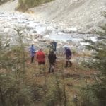
Seven arrived at the South Temple in 2 groups. Group 1 left Weston at 1pm Friday and Group 2 left town at 6pm. Group 1 walked into the South Temple Hut and arrive there just on dark and Group 2 camped the night at the Temple Shelter. Group 2 split further into Group 2A and Group 2B, Group A heading away at first light and arriving at the South Temple Hut at 9ish. Group 2B arriving there some time later. After pitching tents and refreshments, the now mostly combined party (minus 2B) set off up the unnamed branch that ends at the Hut, climbing steeply to reach the top of the tree-line and finding the large cairn put there on a previous occasion 4 years ago when we were last there marking out the same route. As it happened, the old markers were not too bad to locate even though they had faded badly to a silvery grey colour. Using the old markers we were able to tie new orange and pink plastic ribbon and reestablish this as a pretty good route to allow access into the upper basin of this stream which eventually leads around Mt Maitland and Watson Stream and the Ahuriri. Job done and we sat on our laurels in the sun on the hill opposite the Hut at about the bush line where some were so relaxed that they snored! Next day most were up and rearing to go for a walk up the South Temple. Group 2B remained for hut cleaning and other duties. We walked up the valley to where the track splits about 2 hours up and enjoyed the alpine atmosphere and the very mild weather. A return to the hut saw Group 2B departing for the carpark and the rest having lunch and packing up. The return to the carpark was well synchronised with everyone arriving within 5 minutes thereby minimising the exposure to the vicious squadrons descending upon us, some even hiding in the vehicle for a munch on the return journey. A good trip with good company and a good deed done. Thanks to John, Maurice and Phyllis, Jen, Karyl and Nev. Robbie


