

August Monthly Report
There were 26 people present at the August meeting
We were treated to an account of 11 days spent as volunteer wardens on Ulva Island over the last Christmas and New Year, by Brent Wallace and his wife and daughter, The island is 10 minutes by boat from Stewart Island. The first picture we saw set the scene for the rest – a kiwi standing on a track, and pecking at Maria’s boots. We saw pictures of a profusion of birdlife – wekas and chicks, parakeets, kaka, pigeons, tui, morepork and beautiful saddlebacks and also saw and heard videos of a number of these.The dawn chorus was amazing. The hut the family stayed in had solar power and was close to a bush fringed beach with was was a feature of all the island’s beaches , and food was easily harvested – blue cod and abundant shellfish, although much of the island is surrounded by Marine reserve.There are 3-4 km. of formed and signposted track and part of wardens’ duties was to keep them in good order and rubbish free and keep 2 toilets clean. There was a radio call each morning from DOC and 50 traps for rats and other vermin to be regularly checked and reset.Sandflies were not so bad!A dog was being trained during their time there, to sniff out rats, and visitors arriving there are requested to check their gear for seeds and rats. All visitors must leave by dusk. A headstone on private land marks the grave of an early postmaster,Charles Traill, who died in1918, and his wife, Henrietta. Maria discovered that letters can still be written on the back of muttonbird scrub(brachyglottis)leaves.
A truly beautiful and magical place.
The Tramping Club had an interesting month in spite of variable weather.
In mid July, 6 members walked the Heaphy Track .with 3 starting respectively from the Karamea and Collingwood ends, and exchanging car keys at the Mackay Hut where they met and stayed the night. Going south from the top end they stayed at the new Perry Range Hut and climbed Mt. Perry and then over the Gouland Downs, home of the enormous native snail and where 3 blue ducks were seen in a creek, and then Mackay and down to the West Coast and the 32 bed Heaphy Hut with nikau palms and a splendid sunset.Being winter they had encountered about a dozen mountain bikers on the way. They met up with the northwards walking group at Murchison to stay the night before the trip home. The longest distance walked in a day was 24 km. and the weather was good for the whole trip.
During the month there was also a trip up Mt. Ida where increasing depth of snow and decreasing visibility meant that the top was not reached although some went over Little Mt.Ida.
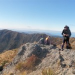
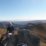
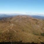
Ben Lomond, off the Waitaki Valley, was climbed by a group of 10 and afforded wonderful 360 degree views from the top. Return was back down the Bridle Track- a 21 km. walk in all with a climb of 1100m. and taking seven and three-quarter hours
.
Wednesday Walkers had some good trips – up Mt. Dryburgh on a round trip and with an excellent view down to the Waitaki Hydro; a group going up Big Ben in good weather encountered knee deep snow.Seven went on to the top.There was a well attended beach walk from Hampden to Moeraki during which a frost fish and a barracuda were collected. From Moeraki groups went variously to the Lookout and by road or round the beach to the Kaiks, and return was back along the beach to Hampden via, in some cases,the Boulders Cafe. A Ngapara farm walk attracted a good group to walk in good weather and experience great views over to the Kakanuis and up the Waitaki Valley,interesting limestone formations and lovely North Otago countryside as well as, by way of contrast, some old vehicles and machinery of interest to a number of the party!
Coming up will be a weekend trip in the Silverpeaks area and a 68 km. bike ride with various options around some good North Otago countryside.
Silverpeaks 23/24 August
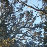
Birds of a feather
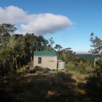
Philip J Cox Hut
A bit late in the posting thereof, but that is what happens when the website goes down and then you go away without your computer. Anyway better late then never. Weather forecast predicted an overcast and SW breeze kind of weekend, not too bad for tramping. Four trampers , just right for the Philip J Cox Hut, a 4 bunker. Down the road, Jane insisting on a coffee stop just south of Waikouaiti from the coffee caravan/ whitebaiter set up, we just went along with it. Up Double Hill Rd and Mountain Rd, getting rougher all the time. We parked just near the locked gate, got changed and walked along the road for the 6km to the start of the Yellow Ridge Track. Its a great day, sun’s out and there is no wind. Down the track to the South Branch of the Waikouaiti R, we were into the native vegetation now and the track was slippery and steep, a bit of a grind to the ridge and then just along to the new 4 bunk hut. After lunch and unpacking we went off to explore the track still marked on the older maps leading down a ridge starting from where the old Yellow Hut used to be…..only to discover that it isn’t there anymore. With only unimaginable bush bashing on offer, we headed back to the Philip J Cox Hut for a fairly relaxed remainder of the afternoon. After a very comfortable night we were away early, keen to make up for the lack of tramping the previous day. Up the ridge to the top and turning north we had a good look around The Gap, that landmark visible from the main road when looking west. Photo’s were taken before heading on to the ABC Cave. A decent sized cave which has had a floor, some seating and a bench built in it. It would sleep 4 easily and will be going on the Trip List for another time. We carried on and an early lunch was had at Jubilee Hut. The weather was quite warm now and a few liters were lost climbing the Devil’s Staircase. The landscape is very dramatic here and we thoroughly enjoyed the day. The views from the to of the ridge were awesome and duly recorded on cameras. Along and along, getting a bit foot weary now, down the ridge and along to the site of the old Green Hut where another late lunch was had. Another hour or so saw us back out to Mountain Rd and a short walk on we found the car and headed back down for an icecream at Palmerston and home. This weekend was very enjoyable, the weather was good and we appreciated the varied and often spectacular landscape right in our own backyard. Thanks to Murray for driving and Jane and John for sharing a good weekend. Robbie
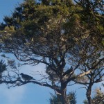
Potential pigeon pie
View from the loo
Spot the Jubilee Hut
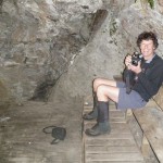
This cave makes me happy
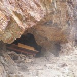
ABC Cave
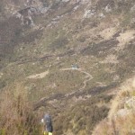
Jubilee Hut
On TB lll 26
Rock and Pillars from TBlll27
Across to Pulpit Rock
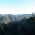
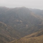
Mt. Ida
Sunday 27th July 2014
A party of nine, consisting of Bill Bews, John Chetwin, Ross Familton, Murray Gifford, Maurice & Phyllis Gray, Dunedin visitors Rodney & Helen Meiklejohn and Trip Organiser Noel Pullan, assembled in the Medway Street car park from 7:45am. After the road access and route details were presented by Noel, we were soon organised into three vehicles and on our way to Wedderburn, via Palmerston and the Pigroot, a few minutes after 8:00am.
Apart from the back seat heckling Noel endured from Ross en-route, the rest of us had a relatively uneventful drive through to Wedderburn and around 9:45am we pulled over to the side of State Highway 85, 3.1 kilometres past Wedderburn, as Noel had turned into what appeared to be the driveway of a farm paddock. As Maurice and I were expecting the nice, metalled road described by Noel earlier and indicated on the Idaburn map as the access road to Little Mount Ida, we assumed that he had taken the wrong turn-off and so we continued on past the Ida Valley-Omakau Road intersection expecting to find this elusive metalled road. However, after further road-side discussions and assurances from Noel (not to mention a couple of bites of humble pie after incorrectly assuming Noel had taken the wrong turn-off), we turned around and headed back to the previous turn-off that he had indeed correctly identified. Our car was left at the gate, just off the main road, so we all continued on towards Little Mount Ida in the two 4WD vehicles on the metalled road obscured by the muddy state of its mid-winter condition. About 7 kilometres later the road took a right-angled turn and began winding its way up Little Mount Ida to the television transmitter and building on top. At this right-angled corner, at 740 metres, we parked the vehicles, put on our gear and got underway at 10:30am. We followed a 4WD track, initially heading north before climbing briefly and turning to the north-east to the base of Mount Ida itself.
The top 200 metres or so of the Ida Range was covered in cloud, which looked particularly cold given the fresh snow that had recently fallen. But, with no real wind to speak of, we carried on; hoping that the sun would eventually break through the overcast sky and the top of the range would also clear. However, it was soon apparent that the cloud probably wasn’t going to lift to accommodate our intentions, so Bill and Phyllis opted to continue along an adjoining 4WD track that headed south-east and up to the saddle between the southern ridge line of Mount Ida and Little Mount Ida, with a view towards making the shorter ascent of Little Mount Ida and descending to the vehicles via the access road. So, we parted company and the remaining seven of us headed straight up the quite step spur leading directly to the summit of Mount Ida over a series of rocky outcrops.
The fresh snow was boot-deep in places and knee-deep in others, dependent upon whether there was rock or vegetation underneath. However, we gained height quickly and by 12:30pm had climbed the steepest part of the spur before stopping for lunch at about 1400 metres, with just one more rocky outcrop remaining to be surpassed in order to gain access to the upper ridge leading to the summit at 1690 metres. But, stopping for lunch revealed just how cold it was without any direct sunlight, and with obvious white-out conditions waiting to envelope us as the cloud was actually lowering, common sense prevailed and so after lunch we turned around and headed back down our ascent route.
We hadn’t seen any sign of Bill and Phyllis since they’d headed off to climb Little Mount Ida, but as Maurice and Ross got down off the Mount Ida spur very quickly, they raced-off along the 4WD track in the direction of Little Mount Ida and made short work of the ascent to the saddle and on to the top. The rest of us made our way back to the vehicles, which were reached by 2:50pm, where Bill and Phyllis had arrived half an hour earlier. Maurice and Ross were soon spotted quickly descending the road on Little Mount Ida and once we were all back together again, the Wedderburn Tavern was elected as the ideal venue for a trip ‘debrief’, over an assortment of beer and coffee.
By the time we were back on the road, around 4:20pm, the top of the Ida Range had finally cleared, as had some of the familiar peaks of the St. Marys Range. Once at Kyeburn, Helen and Rodney headed back to Dunedin via Middlemarch on State Highway 87, with the rest of the party returning to Oamaru via the Pigroot and Palmerston.
Regardless of personal experience gained from years of private excursions into the North Otago ranges and further afield, the company of the wonderful people of the North Otago Tramping and Mountaineering Club and the inestimable combined wealth of knowledge and experience that is freely shared by those long-standing members who provide their services as Trip Organisers, is incomparable. It truly is a privilege to spend a day out in the hills with these people and I would recommend the experience to anyone contemplating such an adventure, whether you’re ultimately considering club membership or are visitors to the club (like us), you are graciously welcomed by one and all.
Thanks very much to John, Murray, Ross, Bill, Maurice & Phyllis and, of course, Noel, for a great day out, regardless of the outcome. It was an absolute pleasure to be in your company.
Rodney & Helen Meiklejohn (Dunedin).
![2014-07-27_10.46a[1]](https://www.notmc.org.nz/wp-content/gallery/mt-ida-27-7-14/2014-07-27_10.46a1.jpg?t=1407326825 "2014-07-27_10.46a[1]")
![2014-07-27_10.46b[1]](https://www.notmc.org.nz/wp-content/gallery/mt-ida-27-7-14/2014-07-27_10.46b1.jpg?t=1406624162 "2014-07-27_10.46b[1]")
![2014-07-27_12.20.51[1]](https://www.notmc.org.nz/wp-content/gallery/mt-ida-27-7-14/2014-07-27_12.20.511.jpg?t=1406624162 "2014-07-27_12.20.51[1]")
![2014-07-27_12.38.50[1]](https://www.notmc.org.nz/wp-content/gallery/mt-ida-27-7-14/2014-07-27_12.38.501.jpg?t=1406624162 "2014-07-27_12.38.50[1]")
![2014-07-27_13.24.26[2]](https://www.notmc.org.nz/wp-content/gallery/mt-ida-27-7-14/2014-07-27_13.24.262.jpg?t=1406624162 "2014-07-27_13.24.26[2]")
![2014-07-27_13.24.38[1]](https://www.notmc.org.nz/wp-content/gallery/mt-ida-27-7-14/2014-07-27_13.24.381.jpg?t=1406624162 "2014-07-27_13.24.38[1]")
![2014-07-27_13.24.54[1]](https://www.notmc.org.nz/wp-content/gallery/mt-ida-27-7-14/2014-07-27_13.24.541.jpg?t=1406624162 "2014-07-27_13.24.54[1]")
![2014-07-27_15.16.10[1]](https://www.notmc.org.nz/wp-content/gallery/mt-ida-27-7-14/2014-07-27_15.16.101.jpg?t=1406624163 "2014-07-27_15.16.10[1]")


July Club Meeting
This hardy group has been out and about despite it being the middle of winter.
Some club members tramped to Big Hut on the Rock and Pillar Range, for the annual midwinter trip where the evening meal culminated with the almost legendary pot luck dessert. The superb new Leaning Lodge hut was a good place to stop for lunch en route. Lake Sutton and Macraes were visited on the journey home the following day.
High river levels meant a trip to Hidden Biv in the Ahuriri Valley became a walk up the zigzag near Ahuriri Base Hut. Walkers encountered snow on the ridge so didn’t linger.
Wednesday Walkers enjoyed a varied month which included Slatey Creek to Belmont Hill, Split Rock at Seacliff and an old graveyard at Bryn’s Point, Dome Hill, Boundary Creek with local ‘historian’ Keith Plunket , and the Waihao Walkway.
Forthcoming Club trips are to Mt Ida from Wedderburn and to Ben Lomond from Campbell Park returning via the Bridal Track.
President Jane shared her experiences on a self-guided bike trip across Europe last year and took us on a fascinating journey through four countries, beginning in Prague in the Czech Republic, then Austria, Slovakia and Hungary – often on rough back roads .
She and her husband Graham, encountered a heatwave in July/August last year and were very glad of iced coffees and cold beers at the end of long days cycling in temperatures of 35-40°C. In one area they encountered trucks spraying water on the road to cool it down. A town in Slovakia had 350 practising dentists. The heat wasn’t the only challenge – very few people they met spoke English and the GPS provided by the tour company frequently proved unhelpful. But they made it, clocking up 1113km in 19 days.
Hidden Biv – Ahuriri Valley, Sunday 13 July 2014
At 7.30am smartly, 5 intrepid members braved the winter chills to visit Hidden Biv in the Ahuriri Valley. A gloomy forecast and rain in the hills over the previous few days was the main topic of conversation as we drove west. After some searching for the right access point down to the Ahuriri River we wandered up and down the river looking for the best place to cross. The river was up at least 500mm and the bottom obscured- we decided to not attempt a crossing and so denied access to the scheduled trip, we chose for option 2 which was to walk up the zigzag near Ahuriri Base Hut which is the track to the Top Dingle Hut. It drizzled to start with but soon dried out and we were treated to sunshine and fantastic views as we climbed out of the valley towards the saddle at approximately 1400m. Not very much snow underfoot just the odd patch as we neared the top. Great views right on the edge of the SW front as it curled around us but it held off until we had had our lunch. It was decided to walk along the ridge south and the front caught up with us and it started to snow and the wind had a sharp edge to it, but it was quite pleasant all the same as we carried on. After an hour or so, about where the permanent tarn is we called it quits as it clagged in and the snow turned to wet sludge. We returned the same way and by the time we reached the top of the zigzag the worst of the blast was over and we were back to the vehicle at about 3pm. Compulsory icecreams were enjoyed at Kurow and we were back home by about 5.30pm declaring that it had been an enjoyable day’s walk and that Hidden Biv would be revealed on another day. Thanks to John, 2 Rosses and Linda for a good outing. Robbie


